It is time again to thank all the frequent, moderate, and rare readers of this blog.
After 238 posts, and views from 145 countries, this blog recently had it's 60,000th page view.
I am particularly grateful to the individuals that take a moment and either comment on the blog or contact me directly to share their thoughts.
A.C.E.
Wednesday, May 31, 2006
Civil 3D 2007 - LandXML White Paper
LandXML is still a mystery to some Land Desktop and Civil 3D users. I enjoy discussing it because LandXML can offer so many NEW options for users when considering sharing, transferring, archiving data, etc.
Recently posted at the Autodesk website is a Whitepaper that discusses the expanded LandXML functionality availible with LandXML 1.1 which is supported by Civil 3D 2007.
Recently posted at the Autodesk website is a Whitepaper that discusses the expanded LandXML functionality availible with LandXML 1.1 which is supported by Civil 3D 2007.
Friday, May 26, 2006
Civil 3D 2007 - Extension for Google Earth
Autodesk made available yesterday the Autodesk Civil 3D 2007 Extension for Google Earth is a NEW Technology Preview that will allow Civil 3d 2007 users to publish significantly more to Google Earth than does the hidden command EXPORTGOOGLEEARTH.
This Extension will allow the exporting of Points, Parcels, Alignments, Corridor models, Surfaces, and Pipe Networks directly to Google Earth.
In order to install you must have both Civil 3D 2007 and any version of Google Earth (Free, Plus, Pro) installed.
Note: When you install you will get two drawings that you can practice exporting to Google earth
Autodesk Vault White Papers
Autodesk Vault has been utilized by the Autodesk's Mechanical Manufacturing products for several years now (5 releases). The referenced webpage contains 5 white papers regarding it.
The 5 white papers are:
Best Practices
Practical Data Management
Data Management Case Studies
Justifying and Implementing Practical Data Management
Vault Remote Access: WAN versus LAN Performance
This should be a decent way to jump start our understanding of Autodesk Vault.
The 5 white papers are:
Best Practices
Practical Data Management
Data Management Case Studies
Justifying and Implementing Practical Data Management
Vault Remote Access: WAN versus LAN Performance
This should be a decent way to jump start our understanding of Autodesk Vault.
Service Pack 1 Coming!
Dave Simeone announced today, during the webcast, that a Service Pack for Civil 3D 2007, will be made available likely during the next week or two.
Thursday, May 25, 2006
3D Texas - New Blog
Mark Reagan of Pflugerville, Texas has started a Civil 3D Blog titled...
3D Texas
As Sir Francis Bacon said, "Nam et ipsa scientia potestas est (Knowledge is power)". Clearly, the Civil 3D knowledge base is ever growing.
I look forward to reading Mark's views.
Note: I thought I had found a new blog. As I was about to post this I see that Dave Dixon already had a link as well.
New Skill Builder
Autodesk has posted a new Skill Builders' topic on their website. It is titled
"Profile and Profile View Styles and Labels"
This set of data and documentation provides details about creating, managing, and using appropriate styles and labels for profiles.
"Profile and Profile View Styles and Labels"
This set of data and documentation provides details about creating, managing, and using appropriate styles and labels for profiles.
Civil 3D 2007 - Project Management Webcast 2 of 2
Tomorrow Mark Scacco will present the second half of the webcasts related to...
Project and Data Management in Civil 3D 2007
This session's focus will be towards setting up users, groups, and permission in Vault, plus procedures and optional plug-ins (and other related items).
The one hour Civil 3D Friday weekly webcast takes place at 9:00 am PDT (12:00 pm EDT).
Project and Data Management in Civil 3D 2007
This session's focus will be towards setting up users, groups, and permission in Vault, plus procedures and optional plug-ins (and other related items).
The one hour Civil 3D Friday weekly webcast takes place at 9:00 am PDT (12:00 pm EDT).
Wednesday, May 17, 2006
Civil 3D 2007 - Project Management Webcast!!!!
There are several reason why you will want to attend this Friday's 1 hour Civil 3D Webcast at 9:00 am Pacific time, 12:00 pm Eastern time. Not the least of which is the subject... "Project Capabilities in Civil 3D 2007". This is the first of two webcast related to this subject.
The Autodesk website describes the session as covering Vault, Vault Explorer, installation of Vault components, logging into Vault, creating projects, and other related topics.
It will be presented by Mark Scacco, President, Engineered Efficiency. Mark has a long history of being a very important resource in the Civil Engineering/Autodesk User community.
In order to benefit from the many enhancements to Civil 3D in a project environment we will need to use Vault. It is a separate application that is integrated with Civil 3D 2007 and is perhaps the most unfamiliar part of migrating to the 2007 product.
Lastly, these webcast are FREE and they are recorded for later viewing.
Upcoming topics include:
5/26/06 – Project and Data Management in Civil 3D 2007
6/2/06 – New Pipe Design and Drafting Capabilities in Civil 3D 2007
6/9/06 – Civil 3D 2007 Site Grading
6/16/06 – Civil 3D 2007 Tips & Tricks
6/23/06 – Increasing Productivity with Civil 3D 2007
6/30/06 - Civil 3D 2007 Corridor Modeling
Tuesday, May 16, 2006
Industry Comment - ENR Cover Story
The cover story of the May 8th issue of ENR Engineering News-Record was titled:
"The Hight Cost of Turnover"
It is a very interesting read regarding how, in this very competitive and staff depleted market, are companies attempting to hold on to their existing employees.
It boils down to employees have the upper hand and companies are getting very creative in efforts to make employees happy.
Civil 3D Rocks - One More Blog
Dana Breig Probert used to have Blog that seemed to have disappeared. Well she has resurrected it with a new address and name. I like the new name more...
Civil 3D Rocks
Civil 3D Rocks
Monday, May 15, 2006
Civil 3D 2007 - Saving Back
I have recently been asked by people, who have opened Civil 3D 2006 drawings in 2007, what can they do to save the data back?
Well, because of the dwg change and thus a change in the definition of objects in Civil 3D 2007 (as compared to earlier versions), it is not possible to simply "save as" to an earlier version and access the intelligent civil data.
So the question is, what options do we have?
TS1056107 offers some guidance.
In order to VIEW drawings, in earlier versions of Civil 3D or in AutoCAD, as proxy graphics (see note below), you will need to use the AutoCAD Save As command.
To EDIT Civil 3D 2007 drawings in earlier versions it is necessary to "Export to AutoCAD" which creates a drawing with all of the intelligent civil data exploded to AutoCAD entities.
TS1056337 mentions that if we "export to AutoCAD while in plan view, the objects will not retain any elevation information.
To retain elevation information we can either explode intelligent civil objects twice to turn them into AutoCAD entities or use the "export to AutoCAD" while in a non-top view.
Lastly, please do not forget that we have the ability to Export to a LandXML file the Civil 3D Data and Import somewhere else. This works for most Civil data even though Civil 3D 2006 uses LandXML 1.0 and Civil 3D 2007 uses LandXML 1.1.
Note: Some users have been experiencing problems with their older drawings when opened in 2007. It has been recommended that they set PROXYGRAPHICS to "0".
New Blog
Dave Dixon a new Civil 3D 2007 user is sharing his reflections about the product in a new blog titled DCA to Civil 3D.
I wish him luck and look forward to seeing his prospective.
I wish him luck and look forward to seeing his prospective.
Civil 3D 2007 - INSUNITS Revisited
I received I call today that made me aware that we will soon be receiving calls from users that will be new to 2007 products that skipped the use of 2006 products. Why?
Do you remember the issue with INSUNITS? If you do not keep reading...
(Much of the following was posted last year, May 31 to be exact, but will certainly become an issue again for new users soon).
It is now VERY necessary to notice what the INSUNITS value is set to for any drawing that you wish to INSERT or XREF. This only mattered in previous versions if you dragged-and-dropped via the DesignCenter.
If the INSUNITS for a source drawing does not match what the current (destination/target) drawing is set to, a scale factor will be applied. This has left some users baffled as to why their drawings with the same base and coordinate location do not land in the same area when inserted or xref'ed.
The INSUNITS value and the factor that will be applied now appear in the INSERT and XREF dialog boxes in the lower right hand corner. Be aware of what they report.
The change can be explained with a quick look into how INSUNITS is defined in HELP.
In 2005 and prior it said:
INSUNITS - Specifies a drawing-units value for automatic scaling of blocks or images dragged from DesignCenter and inserted into a drawing.
In 2006 and 2007 it says:
INSUNITS - Specifies a drawing-units value for automatic scaling of blocks, images, or xrefs inserted or attached to a drawing.
Look at the system variable of INSUNITSDEFSOURCE (Sets source content units value when INSUNITS is set to 0) and INSUNITSDEFTARGET (Sets target drawing units value when INSUNITS is set to 0) also for how drawing can additionally behave.
Wednesday, May 10, 2006
New Blogs
{Corrected}
I have been a little negligent in updating the Blog links in the left column. Here are a few new Blogs that you may find useful.
Cad Insider by Roopinder Tara, Editor of TenLinks (an incredibly useful site for all segments of engineering). I am sure that his Blog will be just as useful.
Civil 3D - In The Trenches by Stephen Sherrill. As a non-reseller he will offer a unique propective. (I saw this in Jason Hickey's Blog)
Lastly, Cadopolis is providing a page that captures many Blog feeds and contains several Topics (channels).
These should be added to the left shortly.
Monday, May 08, 2006
Civil 3D 2007 - Technical Solutions Series (TS1056149)
Civil 3D 2007 includes new drawing templates. Six of them are based on the National CAD Standards version 3.1.
_Autodesk Civil 3D (Imperial) NCS Base.dwt
_Autodesk Civil 3D (Imperial) NCS Classic.dwt
_Autodesk Civil 3D (Imperial) NCS Extended.dwt
_Autodesk Civil 3D (Metric) NCS Base.dwt
_Autodesk Civil 3D (Metric) NCS Classic.dwt
_Autodesk Civil 3D (Metric) NCS Extended.dwt
TS1056149 describes the specifics of these six templates.
Base contains only one style for each object.
Extended contains many styles for each object.
Classic replicates the look of Land Desktop.
Click on the hyperlink above or the title of this post to see the full solution.
This document also mentions that these templates do not contain styles named "Standard" as documented in the "Getting Started Guide".
Civil 3D 2007 - Technical Solutions Series (TS1056340)
Today, I will try something new. As I find Technical Solutions posted in the Autodesk website, that related to Autodesk Civil 3D, that I believe are notable I will provide the link to them.
This is the first. TS1056340 describes why "Minimize Flat Areas" will not affect surfaces created by LandXML.
Why? because "Minimize Flat Areas" is intended to be used on surfaces made from contour data.
Click on the hyperlink above or the title of this post to see the full solution.
This is the first. TS1056340 describes why "Minimize Flat Areas" will not affect surfaces created by LandXML.
Why? because "Minimize Flat Areas" is intended to be used on surfaces made from contour data.
Click on the hyperlink above or the title of this post to see the full solution.
Friday, May 05, 2006
Speaking of Google Earth
As of a week ago Google made SketchUp FREE for personal use.
SketchUp allows you to create 3D models or better yet import .DWG and .DXF and place that data into Google Earth.
Click on the title of this post to get it.
SketchUp allows you to create 3D models or better yet import .DWG and .DXF and place that data into Google Earth.
Click on the title of this post to get it.
Civil 3D 2007 - Corridor to Google Earth
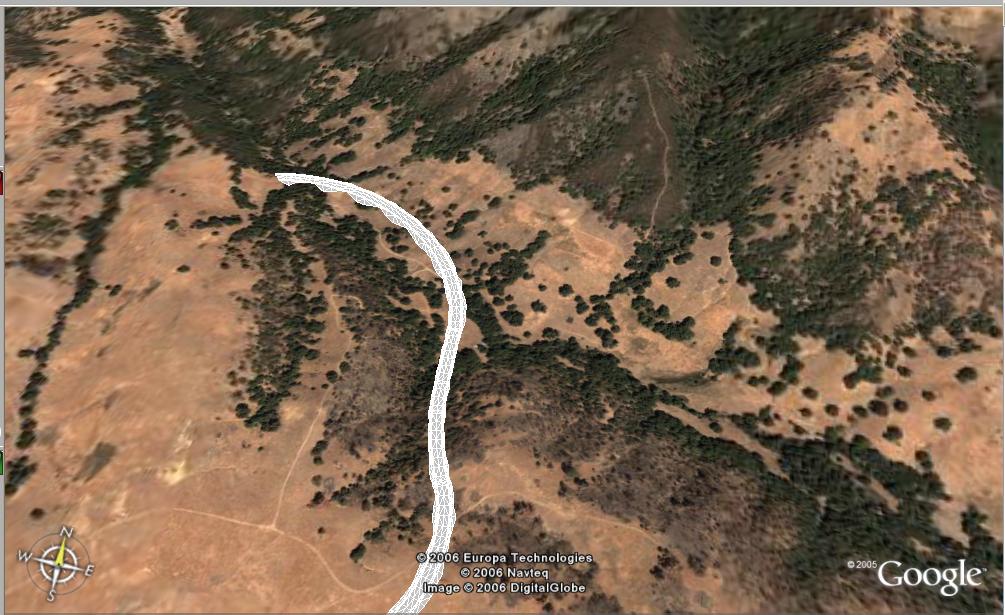
There is so much to share, and not nearly enough time to do so. Here is a super quick item.
Today, during the webcast, Anthony Governanti, Technical Marketing Manager for Autodesk, shared a hidden command in Civil 3D 2007. EXPORTGOOGLEEARTH.
This command allows you to pick a corridor with a corridor surface in a drawing that has a coordinate system assigned and have the surface of the corridor exported to Google Earth.
Wednesday, May 03, 2006
Civil 3D 2007 - Data Shortcuts
Corrected: Thanks to Josh Nelson for the comment!
Before Vault there were data shortcuts. There were two ways to use data shortcuts 1. Through the old project environment (the most common approach). 2. By manually creating, managing, and using them.
Now that projects are handled through Vault, what has happened to data shortcuts?
Well, they still exist. Although, they have changed. Because now they can only be created, managed, and used manually.
The new data shortcuts do require hands-on interaction and attention. But, this manual method is more flexible in that I do not need a project. Now don't get me wrong, in order to share project data Vault is the proper solution. But, data shortcuts have a place in our world. Typically very small projects.
By the way, data shortcuts can now be used for Pipe Networks in addition to Surfaces, Alignment, and Profiles which were always possible.
OK, how do we use them?
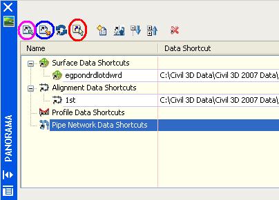
1. In a drawing that contains shortcut-able (I just created that word. Feel free to use it) objects click "General" > "Data Shortcuts" > "Edit Data Shortcuts...".
2. In the "Data Shortcuts" vista of the "Panorama" view click "Create data shortcut by selection" (4th icon, I circled it in red in the image above). Then select the object you wish use via shortcuts.
A shortcut is created but we have to export it by creating an .XML file.
3. In the "Data Shortcuts" vista of the "Panorama" view click "Export data shortcuts to file" (2nd icon, I circled it in blue in the image above). Then Name .XML file.
Now, the shortcut is available for use in another drawing. We now need to create a data reference
4. In a drawing where we wish to use a data shortcut click "General" > "Data Shortcuts" > "Edit Data Shortcuts...".
5. In the "Data Shortcuts" vista of the "Panorama" view click "Import data shortcuts to file" (1st icon, I circled it in magenta in the image above). Then select the .XML file created in step 3.
6. In the "Data Shortcuts" vista of the "Panorama" select the imported shortcut to create a reference for and then click "Create reference" (5th icon, I did not circle it in the image above).
a reference to the shortcut-ed object is then created.
We still get data synchronization messages as before. Remember this can be done without a project.
Tuesday, May 02, 2006
Importing DWF's
In Civil 3D 2007, as with all 2007 products, we are now able to underlay a DWF file straight into our drawings.
How, you may ask? With the DWFATTACH command. DWF files can also be drag-and-dropped into a drawing.
When a DWF that contains multiple layers is attached all of the data is placed (flatted) onto a single layer.
Attached DWFs can be clipped with the DWFCLIP command. They also have adjustable settings for Contrast, Fade, and Monochrome.
If we xref a file that contains an attached dwf, the dwf will be visible in our file (similar to an attached xref).
DWFFRAME controls the visiblity of the DWF file's Frame and whether or not it will plot.
Just remember DWF's are not 100 percent as accurate as a true vector file (DWG) but they are significantly smaller.
DWF Composer = Design Review
If you have visted AUTODESK.COM lately you may have noticed that "Autodesk Composer" is soon to be renamed "Autodesk Design Review".
Subscribe to:
Posts (Atom)
