Wednesday, December 27, 2006
Happy Holidays!
I wish to take a moment to wish you all a very joyous and special holiday season. I am taking a few days off. I hope to be re-energized for the start of the new year.
New Autodesk Home Use Policy Mentioned By Dave
A very important new policy was mentioned by Dave Simeone, Autodesk Civil 3D Senior Product Manager, regarding the use of Autodesk products at home. This is a NEW exclusive benefit for subscription customers only.
Wednesday, December 20, 2006
A.C.E.S. Fly again in January

The Autodesk Civil Engineering Solutions (A.C.E.S.) User Group of Southern California will be holding it's next gathering on Thursday, January 11th, 2007.
Click here for more information and to register.
Land Desktop Service Pack 2A Released
Back on December 11th, Autodesk released Service Pack 2A for the Land Desktop products. Yes, I said products. Depending on which product you use you will need either...
Autodesk Land Desktop 2007 Service Pack 2A
or
Autodesk Civil 3D—Land Desktop Companion 2007 Service Pack 2A
Note: These pages contain information on how to verify the correct version if you are not absolutely certain.
Autodesk Land Desktop 2007 Service Pack 2A
or
Autodesk Civil 3D—Land Desktop Companion 2007 Service Pack 2A
Note: These pages contain information on how to verify the correct version if you are not absolutely certain.
Autodesk University 2007 Save The Dates
In case you wanted to know...
15th Annual Autodesk University
November 27-30, 2007
The Venetian Resort Hotel
Las Vegas, NV. U.S.A.
2005 ~5,500 attendees
2006 ~7,500 attendees
2007 ??????
Personally, AU2006 was the most useful, fulfilling, and memorable event of the year!
15th Annual Autodesk University
November 27-30, 2007
The Venetian Resort Hotel
Las Vegas, NV. U.S.A.
2005 ~5,500 attendees
2006 ~7,500 attendees
2007 ??????
Personally, AU2006 was the most useful, fulfilling, and memorable event of the year!
Tuesday, December 19, 2006
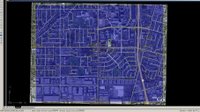
Where On Earth Is This Data?
One of the simplest things that we can do for our drawings that will make them significantly more useful is to assign a Geodetic Zone - Category & Coordinate System for the drawing. If we then use the state plane coordinate data as opposed to an assumed coordinate we will be able to...
1. Intermingle/Gathering data from various other Coordinate Systems seamlessly.
2. Transfer Civil Data from Civil 3D to Google Earth more accurately (vs. UTM or Lat/Long data)
The steps as outline in HELP are as follows:
1. In Toolspace, on the Settings tab, right-click the drawing and click Edit Drawing Settings.
2. In the Drawing Settings dialog box, click the Units and Zone tab.
3. Under Drawing Units, select either Feet or Meters.
4. Under Angular Units, select an angle format.
5. Under Scale, select a scale.
6. From the Categories list, select a zone category.
7. Categories include Lat/Longs, US states, and so on.
When you select a category, the Available Coordinate Systems list displays all the defined zones in that category.
Tip: If you know the coordinate system (CS) code for a zone, you can enter it in the CS Code text box and click OK to select the zone.
8. Select the zone.
9. Click OK.
I did not know what the ground coordinates were for the location of the KETIV Technologies offices here in Fullerton, CA. I did know that we were in NAD83 California State Planes, Zone VI, US Foot (AKA. CA83-VIF). By assigning this to a drawing and some trial and error with the "Publish to Google Earth..." command I now know that the center of our offices are at...
X = 6064787.1131 Y = 2265863.0846 or
Northing = 2,265,863 Easting = 6,064,787
By assigning the Category and Coordinate System my drawing now knows where in the world it is.
Note: Obviously, if all we know is an assumed coordinate location this is NOT possible.
1. Intermingle/Gathering data from various other Coordinate Systems seamlessly.
2. Transfer Civil Data from Civil 3D to Google Earth more accurately (vs. UTM or Lat/Long data)
The steps as outline in HELP are as follows:
1. In Toolspace, on the Settings tab, right-click the drawing and click Edit Drawing Settings.
2. In the Drawing Settings dialog box, click the Units and Zone tab.
3. Under Drawing Units, select either Feet or Meters.
4. Under Angular Units, select an angle format.
5. Under Scale, select a scale.
6. From the Categories list, select a zone category.
7. Categories include Lat/Longs, US states, and so on.
When you select a category, the Available Coordinate Systems list displays all the defined zones in that category.
Tip: If you know the coordinate system (CS) code for a zone, you can enter it in the CS Code text box and click OK to select the zone.
8. Select the zone.
9. Click OK.
I did not know what the ground coordinates were for the location of the KETIV Technologies offices here in Fullerton, CA. I did know that we were in NAD83 California State Planes, Zone VI, US Foot (AKA. CA83-VIF). By assigning this to a drawing and some trial and error with the "Publish to Google Earth..." command I now know that the center of our offices are at...
X = 6064787.1131 Y = 2265863.0846 or
Northing = 2,265,863 Easting = 6,064,787
By assigning the Category and Coordinate System my drawing now knows where in the world it is.

Note: Obviously, if all we know is an assumed coordinate location this is NOT possible.
Monday, December 18, 2006
Vault Questions and Answers
I have been out of town in lovely San Luis Obispo, CA, on business. Prior to going there, and while I was there, I received some inquiries about Vault and Civil 3D. I normally carry a series of documents and white papers about this subject. This trip I left that binder behind.
Today, I found that most of these documents are from this webpage at the Autodesk Website. The documents from this page are:
1. Autodesk Vault and Data Management Questions and Answers 6 Pages
2. Autodesk Civil 3D 2007 - Project Management Workflow Using Autodesk Vault 18 Pages
3. Project Management in Autodesk Civil 3D 2007 94 Pages
4. Remote Vault Access: WAN Versus LAN Performance 2 Pages
5. Managing Your Data for Autodesk Civil 3D 38 Pages
6. Implementation Guide for Autodesk Civil 3D 80 Pages
One Additional Document is from the White Papers Page:
7. Autodesk Civil 3D CAD Manager’s Guide 33 Pages
Clearly, there are many other sources of information about Civil 3D and Vault. These documents are a must have for the reference library of data about Vault seeing as they are from the Mothership (Autodesk) herself.
Note: Some of these documents I had very resently posted about.
Wednesday, December 06, 2006
Want To Double Pick or Right-Click Edit?
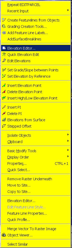
 One of my favorite classes at Autodesk University 2006 (last week) was given by my friend David Garrigues. During the class he described how he had created a CUI with custom Right-Click menus (many commands per object type) and the ability to Double-Pick on an AECC object (Alignment, Surface etc.) and bring up the object's Properties Dialog Box, instead of the AutoCAD Properties Palette. This gives users of this CUI a quicker way to create, edit, interact with, and control their Civil 3D objects. The images to the left show what you see if you bring up the right-click menu while selecting a Surface and Feature Line respectively.
During the class, David mentioned that he would make this CUI available. The simplest way to do so was for him to post it in the "Content Sharing" section of the "Civil Engineering Community" website. It is located in the "Utilities" area of "Content Sharing". It is titled:
"Double and Right Click CUI"
You must be registered and login to the site in order to download this CUI.
Download it and follow the instruction from the readme file to get it installed properly. I have already done so and it makes life a bunch easier.
Thanks Dave!!
Monday, December 04, 2006
NEW! Project Management Document
Newly added to the bottom of the Civil 3D Service Pack 3 page is a document (over 80 pages) titled:
"Project Management in Autodesk Civil 3D 2007".
This is a very comprehensive document prepared specifically for Service Pack 3. The introduction states:
"The content will appear in an updated form in the online User’s Guide for Autodesk Civil 3D 2008."
Sections include:
Transition from Land Desktop
Using External References
Managing Data Using Data Shortcuts
Managing Data Using Vault
Vault Best Practices
Migrating Old Autodesk Civil 3D Projects
Detaching a Drawing from a Project
This is a large and VERY helpful document.
Friday, December 01, 2006
AU2006 What Myths and Legends are made of
I am about to go down to attend my final class. Once the three classes that I gave earlier in the week were over I started attending everything that I could. I mean everything.
There is so much to see, do, learn, listen, touch, play with, try, eat, and drink at Autodesk University it can literally make your head spin.
I intend to post a more formal recap at a later point. Preferably, not from a hotel room. I will have lots of thoughts to share in the coming days and weeks.
MYTH or LEGEND?
Some of the stories of this year's activities, I am sure, will go in to annuls of Autodesk lore. Some occured at the ISD Industry Reception on Wednesday evening at TOA in the Venetian (What a place by the way!). Some may remember. Sadly, others I am sure, will not.
Either way it has been an incredible time!
100,000th Page View
It seems that at some point today the 100,000th page view to this blog will occur. I am now including the page view counter at the bottom of this blog.
If you should be that 100,000th Page view'er make a screen capture and email it to me. I would like to provide an "Angel's Civil 3D Thoughts" blog t-shirt.
Thank you all who introduced yourselves to me this week, and were kind enough to mention that you read this blog. It is good to know that it helps in some small way.
I also wish to thank everyone from whom I have learned from, shared with, and helped with this process. After all, we all have the same goal...
TO BE BETTER!
Subscribe to:
Posts (Atom)
