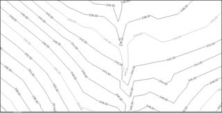
Create Multiple Contour Labels like in Land Desktop using Civil 3D
Procedure:
1. Click Surfaces menu > Labels > Add Contour Labels
2. On the "Create Contour Labels" toolbar, select "Label Multiple Group Interior"

Note: This will enable the Multiple Group Interior edit box where you enter the desired spacing interval.
3. Enter a desired distance for the spacing interval in the field provided

4. Select a start point and endpoint for the contour label line.
5. Repeat Step 4 as needed
6. Press Enter to end the label creation process.

Tip: After creating your contour labels, you may want to turn-off the label line layer and/or make it non-plot-able (By default the contour label lines are placed on the DEFPOINTS layer).
Thanks Daniel I am sure this will help.

1 comment:
Hello Angel,
I'm interested in finding out if you can create contours in AutoCAD civil 3D on a survey drawing with existing spot elevations. Can you help me?
Dennis in Miami
Post a Comment