As announced on the Civil 3D Live Webcasts page, this Friday Dec. 7, 2007 Dave Simeone, Civil 3D Product Manager, will be demonstrating the NEW Storm Sewer Extension for AutoCAD Civil 3D 2008. He will also describe a recommended workflow and how to get it.
Registration is required. Register now.
Showing posts with label Pipes. Show all posts
Showing posts with label Pipes. Show all posts
Wednesday, December 05, 2007


Tuesday, January 23, 2007
Read the Labels
I have now been able to provide "labels" for the majority of the almost 400 posts of this blog.
You will notice at the bottom of most posts what Blogger terms "labels". Other applications might use the term tags. If you pick on a "label" all blog posts that have similar "labels" will be displayed. I accomplished this relatively quickly and not with a fine-tooth comb. So there may be some posts that are not perfectly "label"ed.
This was worth the effort because this can be a good method to find all posts that have to do with a particular subject, such as Vault or Profiles etc.
Give it a try, see if it helps. Feel free to comment about any posts or "labels".
I will add some of the current "labels" to this post, to kick start the process.
You will notice at the bottom of most posts what Blogger terms "labels". Other applications might use the term tags. If you pick on a "label" all blog posts that have similar "labels" will be displayed. I accomplished this relatively quickly and not with a fine-tooth comb. So there may be some posts that are not perfectly "label"ed.
This was worth the effort because this can be a good method to find all posts that have to do with a particular subject, such as Vault or Profiles etc.
Give it a try, see if it helps. Feel free to comment about any posts or "labels".
I will add some of the current "labels" to this post, to kick start the process.
Tuesday, November 28, 2006
AU2006 Day 1
If this is Tuesday we must be talking pipes.
I gave the first of my three class today:
Autodesk Civil 3D Pipe Networks Made Easy.
It is a bit unusual seeing 300-400 faces in a training session. The main session with over 7,000 attendees was a sight to see. Yes, 7,000 people in one room.
I will be giving two Civil Powertrack classes tomorrow.
Autodesk Civil 3D Corridors: Cul-de-Sacs Are Not a Dead End.
Autodesk Civil 3D Grading Made Easy.
I gave the first of my three class today:
Autodesk Civil 3D Pipe Networks Made Easy.
It is a bit unusual seeing 300-400 faces in a training session. The main session with over 7,000 attendees was a sight to see. Yes, 7,000 people in one room.
I will be giving two Civil Powertrack classes tomorrow.
Autodesk Civil 3D Corridors: Cul-de-Sacs Are Not a Dead End.
Autodesk Civil 3D Grading Made Easy.
Monday, October 23, 2006
Autodesk University 2006 Update - Students Galore
Well as of a few moments ago my three classes at Autodesk University now have over 1000 registered attendees combined.
Here are the three classes I am teaching (The second two are a part of the Powertrack and are being recorded):
CV11-2 Civil 3D® Pipe Networks Made Easy 10:30 am - 12:00 pm Nov. 28
CV23-4 Civil 3D® Corridors: Cul-de-Sacs Are Not a Dead End 1:00 pm - 2:30 pm Nov. 29
CV25-3 Civil 3D® Grading Made Easy 5:00 pm - 6:30 pm Nov. 29
These classes have 275, 287 and 439 in enrollment respectively. That is 1001 students. Amazing.
Here are the three classes I am teaching (The second two are a part of the Powertrack and are being recorded):
CV11-2 Civil 3D® Pipe Networks Made Easy 10:30 am - 12:00 pm Nov. 28
CV23-4 Civil 3D® Corridors: Cul-de-Sacs Are Not a Dead End 1:00 pm - 2:30 pm Nov. 29
CV25-3 Civil 3D® Grading Made Easy 5:00 pm - 6:30 pm Nov. 29
These classes have 275, 287 and 439 in enrollment respectively. That is 1001 students. Amazing.
New Webcasts CD
I happen to hold in my hand a brand new CD which contains webcasts recorded between August 1, 2005 and July 31, 2006. This CD contains 42 recorded webcast sorted in the following groups:
Civil 3D General (19 webcasts)
Compatible Products (3 webcasts)
Customer Success (3 Webcasts)
Pipe Design (1 webcast)
Production Drafting (4 webcasts)
Road and Transportaion Design (8 webcasts)
Site and Subdivision Development (4 webcasts)
Additionally there are...
15 Customer Success Stories
6 White Papers
and information about the "Civil Engineering Community"
This CD replaces a CD that had webcasts from August 1, 2005 and January 31, 2006 (18 webcasts). So that means that this new CD contains an additional six months worth of webcasts(24 additional webcasts).
I have always been a BIG fan of the webcast CDs and DVD because I can view them at any time without internet connection. Click above to request yours.
Oh, and did I mention that it is FREE.
Civil 3D General (19 webcasts)
Compatible Products (3 webcasts)
Customer Success (3 Webcasts)
Pipe Design (1 webcast)
Production Drafting (4 webcasts)
Road and Transportaion Design (8 webcasts)
Site and Subdivision Development (4 webcasts)
Additionally there are...
15 Customer Success Stories
6 White Papers
and information about the "Civil Engineering Community"
This CD replaces a CD that had webcasts from August 1, 2005 and January 31, 2006 (18 webcasts). So that means that this new CD contains an additional six months worth of webcasts(24 additional webcasts).
I have always been a BIG fan of the webcast CDs and DVD because I can view them at any time without internet connection. Click above to request yours.
Oh, and did I mention that it is FREE.
Friday, October 06, 2006
Autodesk University 2006 Update
I had previously mentioned that I will be teaching three classes at Autodesk University next month. Last year the one Civil 3D® class that I taught had 194 actual attendees out of the over 200 that signed up. I thought that that was a large group. Well as evidence for the increased demand for Civil 3D instruction, my three classes this year, as of this moment, have 249, 255, and 409 people enrolled in them. These numbers are very eye-opening, and there are still 53 days to register. (By the way, today is the last day to register at the reduced rate of $1495).
Here are the three classes I am teaching (The second two are a part of the Powertrack and are being recorded):
CV11-2 Civil 3D® Pipe Networks Made Easy 10:30 am - 12:00 pm Nov. 28
CV23-4 Civil 3D® Corridors: Cul-de-Sacs Are Not a Dead End 1:00 pm - 2:30 pm Nov. 29
CV25-3 Civil 3D® Grading Made Easy 5:00 pm - 6:30 pm Nov. 29
Here are the three classes I am teaching (The second two are a part of the Powertrack and are being recorded):
CV11-2 Civil 3D® Pipe Networks Made Easy 10:30 am - 12:00 pm Nov. 28
CV23-4 Civil 3D® Corridors: Cul-de-Sacs Are Not a Dead End 1:00 pm - 2:30 pm Nov. 29
CV25-3 Civil 3D® Grading Made Easy 5:00 pm - 6:30 pm Nov. 29
Friday, September 22, 2006
No New Templates Needed!
If you read the Service Pack 2 Readme file, you may have noticed the following section.
Important: The following standard template files (*.dwt) have been recreated due to issues found with Pipe Network Parts Lists. Some Network parts lists may be corrupt if you use .dwt files from the Autodesk Civil 3D 2007 release. The new template files will be posted at http://civilcommunity.autodesk.com/.
Well, it turns out that the templates were fine all along and Autodesk will not be posting new templates. Dan Philbrick, Autodesk Civil 3D Development Manager, stated in the Civil 3D discussion group the following:
"We thought we had an issue with the templates and decided to put a note in the readme. However, we did not want to release new templates unless we really thought it was necessary. Upon further research we found that the existing templates are fine - no need for new templates."
I hope this clarifies some confusion.
Important: The following standard template files (*.dwt) have been recreated due to issues found with Pipe Network Parts Lists. Some Network parts lists may be corrupt if you use .dwt files from the Autodesk Civil 3D 2007 release. The new template files will be posted at http://civilcommunity.autodesk.com/.
Well, it turns out that the templates were fine all along and Autodesk will not be posting new templates. Dan Philbrick, Autodesk Civil 3D Development Manager, stated in the Civil 3D discussion group the following:
"We thought we had an issue with the templates and decided to put a note in the readme. However, we did not want to release new templates unless we really thought it was necessary. Upon further research we found that the existing templates are fine - no need for new templates."
I hope this clarifies some confusion.
Monday, August 14, 2006
My AU Classes
Now that people are starting to sign up for Autodesk University here are the classes that I am teaching this year:
CV11-2: Autodesk® Civil 3D® Pipes Networks Made Easy
CV23-4: Autodesk® Civil 3D® Corridors: Cul-de-Sacs Are Not a Dead End
CV25-3: Autodesk® Civil 3D® Grading Made Easy
I hope to see you there.
CV11-2: Autodesk® Civil 3D® Pipes Networks Made Easy
CV23-4: Autodesk® Civil 3D® Corridors: Cul-de-Sacs Are Not a Dead End
CV25-3: Autodesk® Civil 3D® Grading Made Easy
I hope to see you there.
Thursday, August 03, 2006
Civil 3D - SP2 Coming Soon
Service Pack 2 for Civil 3D 2007 will likely be available sometime next week. It should include Civil 3D 2K7 SP1A, and Map 2K7 SP1 & SP2.
Issues Resolved in Autodesk Civil 3D 2007 Service Pack 2
General
When closing the program, you no longer receive an error message after using the Object Property Manager.
Using the UNDO command after deleting or inserting an elevation point no longer causes the program to close unexpectedly.
Alignments
Version 2006 drawings that contain a Spiral Curve Spiral with the curve radius set to zero can now be migrated to version 2007 and the Spiral Curve Spiral is correctly displayed.
An issue with alignment station equations has been resolved and the station equation labels now display expected results.
Corridor
When pasting surfaces, dynamic corridor surfaces are filtered out of the selection set to avoid a situation dependency. You can create non-dynamically linked corridor surfaces to paste into an existing surface.
Using the DaylightStandard subassembly, you can create a corridor model with a horizontal slope limit and the material thickness will be applied to the horizontal links. Previously the material thickness was not applied to the horizontal links.
Changing a style of an exported corridor surface no longer causes the program to close unexpectedly.
When you specify corridor sections at Superelevation Critical Stations (from the Frequency To Apply Assemblies dialog box) the sections are now added.
Grading
Points and Elevations are now displayed accurately in the Elevation Editor.
There is improved performance using the Weed command on a feature line that was created from a polyline.
Using the Fillet command on feature lines no longer causes the program to close unexpectedly.
There is improved performance when using the Fit Curve command.
An issue with using Feature Line commands in multiple drawings has been resolved.
Using the Weed command now removes the expected points when using a weeding factor of 3D Distance. Previously not all the points that met the weeding factor were removed and all other points were removed.
Using the UNDO command after moving a grading object to a site no longer causes the program to close unexpectedly.
The maximum range for slope patterns is now displayed correctly. Previously, the slope pattern was displayed even though it was outside of the maximum range.
Elevation point z values are recognized when you add a PI to a feature line.
Entering the elevation difference on a new feature line no longer causes the Draw Feature Line command to end.
Creating a grading transition between mixed surface and elevation or distance targets no longer causes the program to close unexpectedly, however this will not result in creating a grading object because Civil 3D cannot find a valid solution for these conditions.
Labels
Using the Parcel Create by Slide Bearing command no longer causes the program to close unexpectedly when the parcel label styles contain custom expressions.
Duplicate entries are no longer created in parcel tables when you insert a new line.
Issues with parcel labels not erasing correctly have been resolved. The program no longer closes unexpectedly when using the erase command on multiple parcel labels. Labels are not redisplayed after using the erase command and then saving the drawing.
The direction arrow component type has been added to the general line label styles.
LandXML
Error messages are no longer displayed when you close a drawing after using the Export LandXML command.
When exporting multiple corridor models using the Export LandXML command the program no longer closes unexpectedly.
Parcels
The UNDO command produces expected results after using grip edits on parcels and no longer causes the program to close unexpectedly.
The UNDO command produces expected results after moving a parcel to another site and no longer causes the program to close unexpectedly.
An issue with converting a closed polyline to a parcel has been resolved.
Using grip edits on parcel lines displays expected results.
An issue with saving user defined properties in a .dwt file has been resolved.
There is improved performance when using the REGEN command for parcels.
Pipes
A set sump depth rule has been added. This rule is not added by default, but can be added to the structure rule set for use during junction structure creation (layout) or by changing all junction structure sump depths at once using the Apply Rules command.
In the Part Builder command, you can use Cyrillic and Asian characters in Catalog chapter names and part names.
When using the Change Flow Direction command, flow arrows are now displayed correctly.
Deleting structures no longer causes the program to close unexpectedly.
There is improved performance when opening version 2006 drawings that contain structure styles. The program no longer forces version 2006 drawings that contain structure styles to display the boundaries as solid.
There is improved performance when using pipe network references.
Points
An issue with editing Point Label Styles from the Point Panorama view has been resolved.
Points can no longer be selected in a viewport when they are on a layer that is frozen for that viewport.
Profiles
The correct information is now displayed in horizontal geometry bands for radius and curvature.
The pipe network band node in the profile view is now displayed in the first drawing you open. Previously, the first drawing you opened in a new session would be missing the node and you had to close and re-open the drawing.
Using the UNDO and REDO commands after deleting a sub-entity from the profile view no longer causes the program to close unexpectedly.
Performing station editing in multiple layout profiles no longer produces an error message.
Project Management
The Migrate Pre-Civil 3D Project command now creates the correct folder structure in the project.
Prospector
The program no longer closes unexpectedly when you close a drawing while the item previews are displayed in Prospector.
The Zoom To command zooms to the correct location after setting the UCS.
Surfaces
Contour smoothing no longer creates segments of zero length on closed contours. Previously the program would close unexpectedly when opening a drawing in which this occurred.
The Smooth Contours command no longer causes gaps in the contour display.
Issues with surface styles have been resolved. The program no longer closes unexpectedly when a surface is created that does not have an assigned style.
Surface labels display the correct values for Surface Slope Horizontal Distance.
The program no longer closes unexpectedly when using the Paste Surface command.
Creating Quick Profiles from a surface no longer causes the program to close unexpectedly.
An issue with the display of render masks has been resolved.
Survey
There is improved performance when importing field book files.
Using the Browse for Folder dialog box when specifying an equipment database path now returns the expected result and no longer causes the program to close.
The MCS survey figure command now starts the multipoint curve at the first point number following the command and ends correctly when other curve commands are processed.
An error message is now displayed stating that the file cannot be opened if you attempt to export a field book file to a network address where you do not have write access. The program no longer closes unexpectedly.
The Show Properties command for control points, non-control points, and directions now displays the properties in the item list view.
After inserting survey points into the drawing, using the Zoom To command from the Prospector shortcut menu for Points or Point Groups now returns correct results.
The program no longer closes unexpectedly when you attempt to close the Traverse Editor.
When using the Traverse Analysis command the Angle error now displays correctly for direction start and end traverse.
The Zoom To and Pan To commands on the Survey collection shortcut menus now return expected results.
The Browse To Observation command now returns expected results.
Changing values for the Interactive Graphics in the User Settings no longer closes the panorama view.
The Equipment Database item view list no longer closes when you right click on an Equipment item, in the list and select Make Current.
Editing Latitude and Longitude values for control points now returns the expected results for the Easting and Northing.
This Service Pack also includes resolution for the following AutoCAD issue:
An issue with slow performance has been improved when you open drawings that contain large numbers of blocks.
Issues Resolved in Autodesk Civil 3D 2007 Service Pack 2
General
When closing the program, you no longer receive an error message after using the Object Property Manager.
Using the UNDO command after deleting or inserting an elevation point no longer causes the program to close unexpectedly.
Alignments
Version 2006 drawings that contain a Spiral Curve Spiral with the curve radius set to zero can now be migrated to version 2007 and the Spiral Curve Spiral is correctly displayed.
An issue with alignment station equations has been resolved and the station equation labels now display expected results.
Corridor
When pasting surfaces, dynamic corridor surfaces are filtered out of the selection set to avoid a situation dependency. You can create non-dynamically linked corridor surfaces to paste into an existing surface.
Using the DaylightStandard subassembly, you can create a corridor model with a horizontal slope limit and the material thickness will be applied to the horizontal links. Previously the material thickness was not applied to the horizontal links.
Changing a style of an exported corridor surface no longer causes the program to close unexpectedly.
When you specify corridor sections at Superelevation Critical Stations (from the Frequency To Apply Assemblies dialog box) the sections are now added.
Grading
Points and Elevations are now displayed accurately in the Elevation Editor.
There is improved performance using the Weed command on a feature line that was created from a polyline.
Using the Fillet command on feature lines no longer causes the program to close unexpectedly.
There is improved performance when using the Fit Curve command.
An issue with using Feature Line commands in multiple drawings has been resolved.
Using the Weed command now removes the expected points when using a weeding factor of 3D Distance. Previously not all the points that met the weeding factor were removed and all other points were removed.
Using the UNDO command after moving a grading object to a site no longer causes the program to close unexpectedly.
The maximum range for slope patterns is now displayed correctly. Previously, the slope pattern was displayed even though it was outside of the maximum range.
Elevation point z values are recognized when you add a PI to a feature line.
Entering the elevation difference on a new feature line no longer causes the Draw Feature Line command to end.
Creating a grading transition between mixed surface and elevation or distance targets no longer causes the program to close unexpectedly, however this will not result in creating a grading object because Civil 3D cannot find a valid solution for these conditions.
Labels
Using the Parcel Create by Slide Bearing command no longer causes the program to close unexpectedly when the parcel label styles contain custom expressions.
Duplicate entries are no longer created in parcel tables when you insert a new line.
Issues with parcel labels not erasing correctly have been resolved. The program no longer closes unexpectedly when using the erase command on multiple parcel labels. Labels are not redisplayed after using the erase command and then saving the drawing.
The direction arrow component type has been added to the general line label styles.
LandXML
Error messages are no longer displayed when you close a drawing after using the Export LandXML command.
When exporting multiple corridor models using the Export LandXML command the program no longer closes unexpectedly.
Parcels
The UNDO command produces expected results after using grip edits on parcels and no longer causes the program to close unexpectedly.
The UNDO command produces expected results after moving a parcel to another site and no longer causes the program to close unexpectedly.
An issue with converting a closed polyline to a parcel has been resolved.
Using grip edits on parcel lines displays expected results.
An issue with saving user defined properties in a .dwt file has been resolved.
There is improved performance when using the REGEN command for parcels.
Pipes
A set sump depth rule has been added. This rule is not added by default, but can be added to the structure rule set for use during junction structure creation (layout) or by changing all junction structure sump depths at once using the Apply Rules command.
In the Part Builder command, you can use Cyrillic and Asian characters in Catalog chapter names and part names.
When using the Change Flow Direction command, flow arrows are now displayed correctly.
Deleting structures no longer causes the program to close unexpectedly.
There is improved performance when opening version 2006 drawings that contain structure styles. The program no longer forces version 2006 drawings that contain structure styles to display the boundaries as solid.
There is improved performance when using pipe network references.
Points
An issue with editing Point Label Styles from the Point Panorama view has been resolved.
Points can no longer be selected in a viewport when they are on a layer that is frozen for that viewport.
Profiles
The correct information is now displayed in horizontal geometry bands for radius and curvature.
The pipe network band node in the profile view is now displayed in the first drawing you open. Previously, the first drawing you opened in a new session would be missing the node and you had to close and re-open the drawing.
Using the UNDO and REDO commands after deleting a sub-entity from the profile view no longer causes the program to close unexpectedly.
Performing station editing in multiple layout profiles no longer produces an error message.
Project Management
The Migrate Pre-Civil 3D Project command now creates the correct folder structure in the project.
Prospector
The program no longer closes unexpectedly when you close a drawing while the item previews are displayed in Prospector.
The Zoom To command zooms to the correct location after setting the UCS.
Surfaces
Contour smoothing no longer creates segments of zero length on closed contours. Previously the program would close unexpectedly when opening a drawing in which this occurred.
The Smooth Contours command no longer causes gaps in the contour display.
Issues with surface styles have been resolved. The program no longer closes unexpectedly when a surface is created that does not have an assigned style.
Surface labels display the correct values for Surface Slope Horizontal Distance.
The program no longer closes unexpectedly when using the Paste Surface command.
Creating Quick Profiles from a surface no longer causes the program to close unexpectedly.
An issue with the display of render masks has been resolved.
Survey
There is improved performance when importing field book files.
Using the Browse for Folder dialog box when specifying an equipment database path now returns the expected result and no longer causes the program to close.
The MCS survey figure command now starts the multipoint curve at the first point number following the command and ends correctly when other curve commands are processed.
An error message is now displayed stating that the file cannot be opened if you attempt to export a field book file to a network address where you do not have write access. The program no longer closes unexpectedly.
The Show Properties command for control points, non-control points, and directions now displays the properties in the item list view.
After inserting survey points into the drawing, using the Zoom To command from the Prospector shortcut menu for Points or Point Groups now returns correct results.
The program no longer closes unexpectedly when you attempt to close the Traverse Editor.
When using the Traverse Analysis command the Angle error now displays correctly for direction start and end traverse.
The Zoom To and Pan To commands on the Survey collection shortcut menus now return expected results.
The Browse To Observation command now returns expected results.
Changing values for the Interactive Graphics in the User Settings no longer closes the panorama view.
The Equipment Database item view list no longer closes when you right click on an Equipment item, in the list and select Make Current.
Editing Latitude and Longitude values for control points now returns the expected results for the Easting and Northing.
This Service Pack also includes resolution for the following AutoCAD issue:
An issue with slow performance has been improved when you open drawings that contain large numbers of blocks.
Friday, July 21, 2006
Dave & Dan Show co-Starring Anthony a Big Hit!
Today's Civil 3D webcast titled "Dave and Dan Show" was worthwhile. Dave Simeone, Civil 3D Product Manager, and Dan Philbrick, Civil 3D Development Manager along with Anthony Governanti ISD Technical Marketing Manager provided an excellent fast and furious (on-the-fly) Q & A session.
They attempted to answer and demonstate as many posted questions from viewers at home, I mean at work, that they could fit into one hour.
They covered subjects like...
Showing a crossing pipe in a profile
Labeling a crossing Pipe in profile
Creating ROW parcels
Renumbering parcels
Parcel display order
Using surface styles
Editing surface styles
Using the TOOLBOX (new in 2007)
They previewed a utility that should be free and available shortly
Rotating point labels
Transparent commands
Design curb return profiles (using Transparent commands)
Using the Inquiry Tool
Listing Points
Clearly a lot was covered. If you missed it, or if you blinked, Look for this webcast to be available soon among the recorded sessions.
They attempted to answer and demonstate as many posted questions from viewers at home, I mean at work, that they could fit into one hour.
They covered subjects like...
Showing a crossing pipe in a profile
Labeling a crossing Pipe in profile
Creating ROW parcels
Renumbering parcels
Parcel display order
Using surface styles
Editing surface styles
Using the TOOLBOX (new in 2007)
They previewed a utility that should be free and available shortly
Rotating point labels
Transparent commands
Design curb return profiles (using Transparent commands)
Using the Inquiry Tool
Listing Points
Clearly a lot was covered. If you missed it, or if you blinked, Look for this webcast to be available soon among the recorded sessions.
Thursday, June 29, 2006
Civil 3D 2007 - Service Pack 1A Now Available
Service Pack 1A is now available for download. It includes Service Pack 1, plus it addresses additional items.
General - 1 Additional item
Alignment - 1 Additional item
Labels - 2 New items
Pipes - 2 Additional items
General - 1 Additional item
Alignment - 1 Additional item
Labels - 2 New items
Pipes - 2 Additional items
Thursday, June 15, 2006
Civil 3D 2007 - Service Pack 1 Now Available
I just walked in from an appointment and checked to see if Service Pack 1 was available. YES IT IS!
Now, what's in it?
A review of the README file describes the following areas as having issues resolved (look to it for specific details):
General (7 Items)
Alignments (3 Items)
Corridors (4 Items)
Grading (5 Items)
Pipes (2 Items)
Points (3 Items)
Quantity Takeoff Reports (7 Items)
Survey (9 Items)
AutoCAD (1 Item)
Lets hope this allows the product to achieve more of its potential.
Now, what's in it?
A review of the README file describes the following areas as having issues resolved (look to it for specific details):
General (7 Items)
Alignments (3 Items)
Corridors (4 Items)
Grading (5 Items)
Pipes (2 Items)
Points (3 Items)
Quantity Takeoff Reports (7 Items)
Survey (9 Items)
AutoCAD (1 Item)
Lets hope this allows the product to achieve more of its potential.
Tuesday, June 06, 2006
Autodesk University 2006
It is that time again. The first mentions of Autodesk University 2006 to be held at the Venetian Resort Hotel in Las Vegas Nevada from Tuesday November 28 through Friday December 1.
You can save $500 if you take advantage Early-Bird Registrations which will be from August 7 through October 6.
You may wish to mark these dates and start making plans.
Last year, there were somewhere over 5,000 participants. There are many reasons to attend, just review the website to find yours.
Hopefully, I will see you there.
Why do I mention this now, you may ask? I was notified that I had three classes accepted for this year. They are...
Autodesk® Civil 3D® Pipes Networks Made Easy
Class Type: 1.5hr Class
Class Code: CV11-2
Level: All Levels
Date: 11/28/2006
Time: 10:30 am - 12:00 pm
Autodesk® Civil 3D® Corridors: Cul-de-Sacs Are Not a Dead End
Class Type: 1.5hr Class
Class Code: CV23-4
Level: Intermediate
Date: 11/29/2006
Time: 1:00 pm - 2:30 pm
Autodesk® Civil 3D® Grading Made Easy
Class Type: 1.5hr Class
Class Code: CV25-3
Level: All Levels
Date: 11/29/2006
Time: 5:00 pm - 6:30 pm
You can save $500 if you take advantage Early-Bird Registrations which will be from August 7 through October 6.
You may wish to mark these dates and start making plans.
Last year, there were somewhere over 5,000 participants. There are many reasons to attend, just review the website to find yours.
Hopefully, I will see you there.
Why do I mention this now, you may ask? I was notified that I had three classes accepted for this year. They are...
Autodesk® Civil 3D® Pipes Networks Made Easy
Class Type: 1.5hr Class
Class Code: CV11-2
Level: All Levels
Date: 11/28/2006
Time: 10:30 am - 12:00 pm
Autodesk® Civil 3D® Corridors: Cul-de-Sacs Are Not a Dead End
Class Type: 1.5hr Class
Class Code: CV23-4
Level: Intermediate
Date: 11/29/2006
Time: 1:00 pm - 2:30 pm
Autodesk® Civil 3D® Grading Made Easy
Class Type: 1.5hr Class
Class Code: CV25-3
Level: All Levels
Date: 11/29/2006
Time: 5:00 pm - 6:30 pm
Friday, June 02, 2006
Autodesk Official Training Courseware Civil 3D 2007 - Essentials
Autodesk has recently released the 2007 versions of their Essentials training courseware.
The book contains 40 exercises, including 5 new exercises on how to...
"Create and Apply Label Styles"
"Check Files In and Out of the Vault"
"Create and Apply Pipe Network Rules"
"Import a Survey Control Network"
"Modify Survey Database Settings"
This book is likely the foundation of most training that is available. Although any reseller worth their salt (KETIV Technologies, wink) supplements this training with lots of additional content.
I have not yet found a link from the Autodesk website. But you can contact your reseller if you are interested.
The book contains 40 exercises, including 5 new exercises on how to...
"Create and Apply Label Styles"
"Check Files In and Out of the Vault"
"Create and Apply Pipe Network Rules"
"Import a Survey Control Network"
"Modify Survey Database Settings"
This book is likely the foundation of most training that is available. Although any reseller worth their salt (KETIV Technologies, wink) supplements this training with lots of additional content.
I have not yet found a link from the Autodesk website. But you can contact your reseller if you are interested.
Friday, May 26, 2006
Civil 3D 2007 - Extension for Google Earth
Autodesk made available yesterday the Autodesk Civil 3D 2007 Extension for Google Earth is a NEW Technology Preview that will allow Civil 3d 2007 users to publish significantly more to Google Earth than does the hidden command EXPORTGOOGLEEARTH.
This Extension will allow the exporting of Points, Parcels, Alignments, Corridor models, Surfaces, and Pipe Networks directly to Google Earth.
In order to install you must have both Civil 3D 2007 and any version of Google Earth (Free, Plus, Pro) installed.
Note: When you install you will get two drawings that you can practice exporting to Google earth
This Extension will allow the exporting of Points, Parcels, Alignments, Corridor models, Surfaces, and Pipe Networks directly to Google Earth.
In order to install you must have both Civil 3D 2007 and any version of Google Earth (Free, Plus, Pro) installed.
Note: When you install you will get two drawings that you can practice exporting to Google earth
Wednesday, May 17, 2006
Civil 3D 2007 - Project Management Webcast!!!!
There are several reason why you will want to attend this Friday's 1 hour Civil 3D Webcast at 9:00 am Pacific time, 12:00 pm Eastern time. Not the least of which is the subject... "Project Capabilities in Civil 3D 2007". This is the first of two webcast related to this subject.
The Autodesk website describes the session as covering Vault, Vault Explorer, installation of Vault components, logging into Vault, creating projects, and other related topics.
It will be presented by Mark Scacco, President, Engineered Efficiency. Mark has a long history of being a very important resource in the Civil Engineering/Autodesk User community.
In order to benefit from the many enhancements to Civil 3D in a project environment we will need to use Vault. It is a separate application that is integrated with Civil 3D 2007 and is perhaps the most unfamiliar part of migrating to the 2007 product.
Lastly, these webcast are FREE and they are recorded for later viewing.
Upcoming topics include:
5/26/06 – Project and Data Management in Civil 3D 2007
6/2/06 – New Pipe Design and Drafting Capabilities in Civil 3D 2007
6/9/06 – Civil 3D 2007 Site Grading
6/16/06 – Civil 3D 2007 Tips & Tricks
6/23/06 – Increasing Productivity with Civil 3D 2007
6/30/06 - Civil 3D 2007 Corridor Modeling
The Autodesk website describes the session as covering Vault, Vault Explorer, installation of Vault components, logging into Vault, creating projects, and other related topics.
It will be presented by Mark Scacco, President, Engineered Efficiency. Mark has a long history of being a very important resource in the Civil Engineering/Autodesk User community.
In order to benefit from the many enhancements to Civil 3D in a project environment we will need to use Vault. It is a separate application that is integrated with Civil 3D 2007 and is perhaps the most unfamiliar part of migrating to the 2007 product.
Lastly, these webcast are FREE and they are recorded for later viewing.
Upcoming topics include:
5/26/06 – Project and Data Management in Civil 3D 2007
6/2/06 – New Pipe Design and Drafting Capabilities in Civil 3D 2007
6/9/06 – Civil 3D 2007 Site Grading
6/16/06 – Civil 3D 2007 Tips & Tricks
6/23/06 – Increasing Productivity with Civil 3D 2007
6/30/06 - Civil 3D 2007 Corridor Modeling
Wednesday, May 03, 2006
Civil 3D 2007 - Data Shortcuts
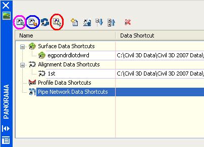
Corrected: Thanks to Josh Nelson for the comment!
Before Vault there were data shortcuts. There were two ways to use data shortcuts 1. Through the old project environment (the most common approach). 2. By manually creating, managing, and using them.
Now that projects are handled through Vault, what has happened to data shortcuts?
Well, they still exist. Although, they have changed. Because now they can only be created, managed, and used manually.
The new data shortcuts do require hands-on interaction and attention. But, this manual method is more flexible in that I do not need a project. Now don't get me wrong, in order to share project data Vault is the proper solution. But, data shortcuts have a place in our world. Typically very small projects.
By the way, data shortcuts can now be used for Pipe Networks in addition to Surfaces, Alignment, and Profiles which were always possible.
OK, how do we use them?
1. In a drawing that contains shortcut-able (I just created that word. Feel free to use it) objects click "General" > "Data Shortcuts" > "Edit Data Shortcuts...".
2. In the "Data Shortcuts" vista of the "Panorama" view click "Create data shortcut by selection" (4th icon, I circled it in red in the image above). Then select the object you wish use via shortcuts.
A shortcut is created but we have to export it by creating an .XML file.
3. In the "Data Shortcuts" vista of the "Panorama" view click "Export data shortcuts to file" (2nd icon, I circled it in blue in the image above). Then Name .XML file.
Now, the shortcut is available for use in another drawing. We now need to create a data reference
4. In a drawing where we wish to use a data shortcut click "General" > "Data Shortcuts" > "Edit Data Shortcuts...".
5. In the "Data Shortcuts" vista of the "Panorama" view click "Import data shortcuts to file" (1st icon, I circled it in magenta in the image above). Then select the .XML file created in step 3.
6. In the "Data Shortcuts" vista of the "Panorama" select the imported shortcut to create a reference for and then click "Create reference" (5th icon, I did not circle it in the image above).
a reference to the shortcut-ed object is then created.
We still get data synchronization messages as before. Remember this can be done without a project.
Friday, April 28, 2006
Civil 3D 2007 - New Features Workshop

One of the very useful items that I refer to often is the "New Features Workshop" this is a Flash based interface that provides information about what was introduced in Civil 3D 2007. This is similar to what AutoCAD has had available for several releases.
The interface is broken down into four sections with multiple topics and subtopics (topics are listed below, but not the many subtopics):
Create
Survey Data
Alignments and Profiles
Pipe Networks
Points
Surfaces
Analyze
Survey Data
Design Evaluation
Grading Tools
Share
Project Management
Export Data
Produce
Labels and Label Styles
Profile and Profile View Labels
Reports Manager
I had hoped to post this yesterday, but I was out doing training all day. What do you know, this was also mentioned during today's Civil 3D Webcast.
Wednesday, April 19, 2006
AUGI CAD Camp Follow up
Yesterday, we at KETIV Technologies hosted an AUGI CAD Camp here in Orange County, California.
Among the many classes available, John Rodriguez and I conducted three class on Civil 3D 2006:
Styles
Grading
Pipe Networks
Based on the feedback, the classes were well received, and show that there is a significant interest in Civil 3D and how it will be adopted.
We also had a brief "Lunch and Learn" about Civil 3D 2007 where some of the more useful new capabilities were demonstrated.
Oh, and by the way, I read in the Civil 3D discussion group that someone here in California received their Civil 3D 2007 subscription fulfillment today.
Among the many classes available, John Rodriguez and I conducted three class on Civil 3D 2006:
Styles
Grading
Pipe Networks
Based on the feedback, the classes were well received, and show that there is a significant interest in Civil 3D and how it will be adopted.
We also had a brief "Lunch and Learn" about Civil 3D 2007 where some of the more useful new capabilities were demonstrated.
Oh, and by the way, I read in the Civil 3D discussion group that someone here in California received their Civil 3D 2007 subscription fulfillment today.
Saturday, April 15, 2006
Bootcamp Day Five - Three Homeruns
Thursday was my fifth and final day at bootcamp. It turned out to be my favorite one.
Why? Well, Autodesk hit three homeruns with me. One for each of the subjects that I covered that day.
HOMERUN #1
Pipes: The additions to pipes were excellent. New rules for both pipes and structures. Structure properties that include pipe inverts that can be edited. Rules can be reapplied at my choosing. Create a network from a pline. Create an alignment from a network. Import LDT pipe runs. Interference checking for collisions or clearance (COOL!). New grips in profile.
HOMERUN #2
Corridors: Lots here too. Many new spiral types. Constrained profiles (similar to horizontal alignments, Fixed, Floating, Free). Floating parabolic curves can now end a profile. Three new transparent commands (profile station from plan view, profile station and elevation from plan view, and profile station and elevation from plan view and point). Profile geometry point can now be labeled in plan views. Customizable markers replace hard-coded ones. Quick profiles, which can include the baseline geometry itself. Two new profile bands: Sectional data and Pipe Network data. Corridors regions can have styles (outlines). Graphical edit can be done. Individual sections can be edited. Corridor surfaces are true surfaces on Prospector tab. 16 new subassemblies. Two new tables: Total Volumes, Materials.
HOMERUN #3
General Drafting: We will now have a Toolbox tab to the Toolspace. This will include reports, but can include custom created tools. Text masking can be added to ALL labels, they can also have a draw order specified. There is now a NOTE label for any text item. We can label basic lines and curves. Reference text in labels can be created from any combination of object(s). Expressions allow us to due math computation with object data (EXCELLENT!!!). We will be able to copy label components. Drag-and-Drop styles will now prompt to Overwrite or Rename. And perhaps my favorite of all EDIT INDIVIDUAL LABEL TEXT VALUES.
It was a very useful and educational week. As you can see there is much to learn, absorb, and incorporate into our habits. That being said, I am sure glad to be home.
I'll be back soon with more detailed posts.
Why? Well, Autodesk hit three homeruns with me. One for each of the subjects that I covered that day.
HOMERUN #1
Pipes: The additions to pipes were excellent. New rules for both pipes and structures. Structure properties that include pipe inverts that can be edited. Rules can be reapplied at my choosing. Create a network from a pline. Create an alignment from a network. Import LDT pipe runs. Interference checking for collisions or clearance (COOL!). New grips in profile.
HOMERUN #2
Corridors: Lots here too. Many new spiral types. Constrained profiles (similar to horizontal alignments, Fixed, Floating, Free). Floating parabolic curves can now end a profile. Three new transparent commands (profile station from plan view, profile station and elevation from plan view, and profile station and elevation from plan view and point). Profile geometry point can now be labeled in plan views. Customizable markers replace hard-coded ones. Quick profiles, which can include the baseline geometry itself. Two new profile bands: Sectional data and Pipe Network data. Corridors regions can have styles (outlines). Graphical edit can be done. Individual sections can be edited. Corridor surfaces are true surfaces on Prospector tab. 16 new subassemblies. Two new tables: Total Volumes, Materials.
HOMERUN #3
General Drafting: We will now have a Toolbox tab to the Toolspace. This will include reports, but can include custom created tools. Text masking can be added to ALL labels, they can also have a draw order specified. There is now a NOTE label for any text item. We can label basic lines and curves. Reference text in labels can be created from any combination of object(s). Expressions allow us to due math computation with object data (EXCELLENT!!!). We will be able to copy label components. Drag-and-Drop styles will now prompt to Overwrite or Rename. And perhaps my favorite of all EDIT INDIVIDUAL LABEL TEXT VALUES.
It was a very useful and educational week. As you can see there is much to learn, absorb, and incorporate into our habits. That being said, I am sure glad to be home.
I'll be back soon with more detailed posts.
Subscribe to:
Posts (Atom)
