Showing posts with label Corridors. Show all posts

Friday, May 02, 2008

Think of the Possibilities - Dynamic Feature Lines from a Corridor

Some of you may have heard by now that Civil 3D 2009 allows for feature lines that are extracted from a corridor to be dynamically linked to the corridor (see next two images).


This ability should lead to some very creative solutions to design challenges. I absolutely look forward to seeing the inventiveness of some users with this behavior.

To get the creativity ball rolling, I spent a little time on a proof of concept that others had suggested should be possible. Here is just one example of what can be done...

In the next image, first notice that the daylighting is accomplished via a grading as opposed to a daylight subassembly (top arrows). The orange objects are feature lines that have been extracted from the corridor, and made dynamic to it. The cyan arcs (curb return) are feature lines that I added manually, that are connected to the ends of the corridor extracted feature lines. Lastly, notice that the design profile (arrow in the lower left hand viewport) is below the existing ground profile.


The next image is the result of ONE change. That one change was editing the design profile (arrow in the lower left viewport) via a grip edit to be above the existing ground profile. the rest is the result of the corridor rebuilding, the feature lines dynamically remaining linked to the corridor and those feature lines updating the cyan feature line that I add by hand (because they share a common endpoint), and of course the gradings updating as well (2 top arrows) from cut to fill.


Big deal you may be saying. Well think about it. In previous versions I would have had to modify a curb return profile as well, to ensure that the curb lines stay aligned. In this example that was not necessary, as a matter of fact there are no curb alignments, nor profiles.

Talk about a game changer. This ability should also allow us to create cross-gutter flow lines that will auto-magically remain linked without the need for extra alignments or profiles. I also created four dynamically linked feature lines on each corridor, but I could have accomplished similar with only one feature line and gradings from that one, in the curb return area.

Where once I needed 12 alignments and corresponding profiles to do a full intersection with cross-gutters and spandrells, I can do it with only two.

Just Think of the possibilities.


Be Better... Don't do things the old way!

Tuesday, January 23, 2007

Read the Labels

I have now been able to provide "labels" for the majority of the almost 400 posts of this blog.

You will notice at the bottom of most posts what Blogger terms "labels". Other applications might use the term tags. If you pick on a "label" all blog posts that have similar "labels" will be displayed. I accomplished this relatively quickly and not with a fine-tooth comb. So there may be some posts that are not perfectly "label"ed.

This was worth the effort because this can be a good method to find all posts that have to do with a particular subject, such as Vault or Profiles etc.

Give it a try, see if it helps. Feel free to comment about any posts or "labels".

I will add some of the current "labels" to this post, to kick start the process.

Wednesday, November 08, 2006

Cul-De-Sacs Fix in SP3

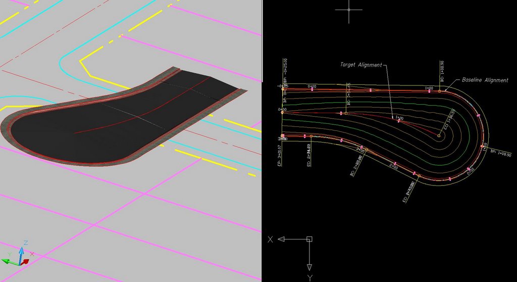
Dan Philbrick, Autodesk Civil 3D Software Development Manager, mentioned in his blog, in the Civil Engineering Community, that Service Pack 3 fixes an issue that has existed when trying to design cul-de-sac corridors with arcs in the centerline alignment.

If our baseline was run around the cul-de-sac bulb entirely as one alignment and had as its target an centerline alighnment with an arc, the assemblies would not solve correctly and leave a flat teardrop shaped gap in the middle of the corridor. This did not happen if the centerline alignment was a tangent (straight).

The necessary workaround was to create two alignments around the bulb of the cul-de-sac each targeting the centerline alignment with the arc.

With the fix provide by Service Pack 3 we no longer need to create the two alignments and can accomplish this goal with one alignment if we so choose.


I went back through the ...README.htm file to see if this was mentioned. I could not find any mention of it. Either way this is a very good thing.

Too bad my Autodesk University "Cul-de-Sacs Are Not a Dead End" class handouts were already submitted. Oh well, I will just have to mention that that was fixed.

Monday, November 06, 2006

Zoom, Zoom, Zoom

I have been building and editing corridors this afternoon. I LOVE the 2X faster corridor builds. Whereas in the past I would store up some edits and rebuild in order to be efficient. I have been rebuilding (applying) edits one at a time. Because of the fact that Civil 3D 2007 Service Pack 3 corridor rebuilds are at least twice as fast (sometimes more) I have been seeing my edits quicker.

This particular corridor is about 1,300 feet of rehab work (sawcutting and widening in a very irregular way).

Autodesk, a BIG thumbs up for this.

Monday, October 23, 2006

Civil 3D - SP3 Update

Just a reminder that there will be a Service Pack 3 for Civil 3D 2007. It is expected in the next two weeks. We have been told that it will...

Restore non-projects shortcuts (with this some will choose to not implement Vault)
Performance improvements (such as 2X faster corridor processing, 5X faster contour label regen and more).
Includes most recent Service Packs for AutoCAD® 2007, Autodesk Map® 3D 2007, and Autodesk® Vault 5.

Tuesday, October 17, 2006

We Wish, Jeff Shares

Jeff Mishler, of Santa Rosa, CA, has created some lisp & VBA routines that he has made available for all to benefit from. The most recent one that I have seen addresses a request that someone had in the Civil 3D discussion group. They asked for a routine, similar to a Land Desktop command, that would "list all available point numbers". Jeff's routine named FreeNums does just that.

Jeff has also created a routine that is currently being shared in the Civil Engineering Community. The lisp routine named "Alignment Tooltips tools.lsp" turns tooltips on/off for all or selected alignments. (You have to be registered with the community in order to download this file.)

Rotate_Markers allows users to to rotate the marker and labels of selected points. (For this one you will have scroll down and find the code in order to copy and paste it and save to a .lsp file)

Lastly, the Rebuild_All_Corridors (copy and paste required here as well) routine rebuilds all selected corridors or if none are selected it rebuilds ALL corridors.

I would personally like that thank Jeff for being generous enough to share these tools, and his talents, with our entire community.

He shared with me the fact that he usually monitors the Civil 3D Wishes Discusion Group, and the fact that he looks for code/solutions/workarounds for just about every wish. So, if you have a wish for a command or capability in Civil 3D do not hesitate to ask for it in the Wishes Discussion Group. Best case someone (ie. Autodesk, Jeff, or someone him) will answer your wish. No need for a genie.

Monday, October 09, 2006

Civil 3D 2007 SP3 Info

During the webcast on Friday Oct 06, 2006 Dave Simeone, Autodesk Civil 3D Product Manager, gave some glimpses of what may likely be in Civil 3D 2007 Service Pack 3. These items include:

Civil 3D 2007 (SP1a, SP2 and NEW FIXES)
AutoCAD 2007 SP1
Map 3D 2007 SP3
Components of Vault SP1 (he made it clear, DO NOT INSTALL VAULT SP1 YET!)

He mentioned that users will likely see the following improvements:

2X Faster Corridor Processing Speed
50X Performance Jump in Project/Reference Interaction
Improved Surface Memory Usage (surface memory leaks have been an issue for some)
Stability Improvements
and (drum roll, please)
Restoration of Non-Projects Shortcuts

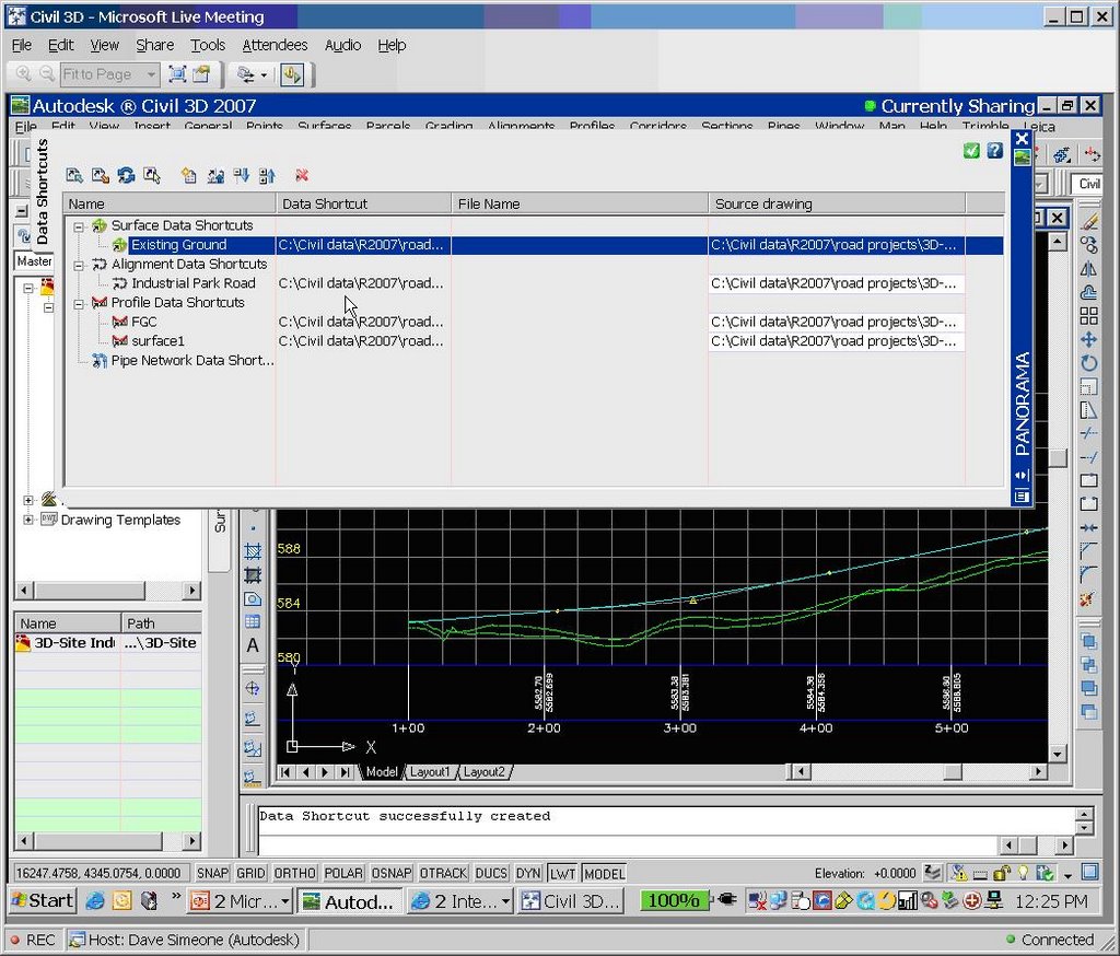
This last item translates to shortcuts that WILL ABSOLUTELY be remembered from session to session. No longer will we have to reload the .xml file from which we load data references. Remember data reference synchronization notifications. He also demonstrated a NEW ability to change the source file of a data reference (see image below).


So when is all this supposed to be available? They are aiming for the end of this month (October).

Monday, August 21, 2006

Roundabout Workflow Guide

Jack Strongitharm, Autodesk Civll 3D Technical Sales Manager (UK and Ireland), has just posted a new workflow guide titled:

Design of Roundabouts using Corridor Models (Part 1 of 2)

This is a 42 page paper that gives a very thorough understanding of the major considerations for roundabout (traffic circle) design with a corridor object in Civil 3D 2007. The second part of the document will address "mini roundabouts".

Thanks Jack and all involved in the preparation of this document. I look forward to Part 2.

Note: This is officially the 300th post to this blog over the last two years. If you wish to find a post about a particular subject, doing an internet search will likely turn up past posts about the subject matter. Unfortunately, the Blogger "Search this blog" option does not search the full two years.

Thursday, August 03, 2006

Civil 3D - SP2 Coming Soon

Service Pack 2 for Civil 3D 2007 will likely be available sometime next week. It should include Civil 3D 2K7 SP1A, and Map 2K7 SP1 & SP2.

Issues Resolved in Autodesk Civil 3D 2007 Service Pack 2

General

When closing the program, you no longer receive an error message after using the Object Property Manager.

Using the UNDO command after deleting or inserting an elevation point no longer causes the program to close unexpectedly.

Alignments

Version 2006 drawings that contain a Spiral Curve Spiral with the curve radius set to zero can now be migrated to version 2007 and the Spiral Curve Spiral is correctly displayed.

An issue with alignment station equations has been resolved and the station equation labels now display expected results.

Corridor

When pasting surfaces, dynamic corridor surfaces are filtered out of the selection set to avoid a situation dependency. You can create non-dynamically linked corridor surfaces to paste into an existing surface.

Using the DaylightStandard subassembly, you can create a corridor model with a horizontal slope limit and the material thickness will be applied to the horizontal links. Previously the material thickness was not applied to the horizontal links.

Changing a style of an exported corridor surface no longer causes the program to close unexpectedly.

When you specify corridor sections at Superelevation Critical Stations (from the Frequency To Apply Assemblies dialog box) the sections are now added.

Grading

Points and Elevations are now displayed accurately in the Elevation Editor.

There is improved performance using the Weed command on a feature line that was created from a polyline.

Using the Fillet command on feature lines no longer causes the program to close unexpectedly.

There is improved performance when using the Fit Curve command.

An issue with using Feature Line commands in multiple drawings has been resolved.

Using the Weed command now removes the expected points when using a weeding factor of 3D Distance. Previously not all the points that met the weeding factor were removed and all other points were removed.

Using the UNDO command after moving a grading object to a site no longer causes the program to close unexpectedly.

The maximum range for slope patterns is now displayed correctly. Previously, the slope pattern was displayed even though it was outside of the maximum range.

Elevation point z values are recognized when you add a PI to a feature line.

Entering the elevation difference on a new feature line no longer causes the Draw Feature Line command to end.

Creating a grading transition between mixed surface and elevation or distance targets no longer causes the program to close unexpectedly, however this will not result in creating a grading object because Civil 3D cannot find a valid solution for these conditions.

Labels

Using the Parcel Create by Slide Bearing command no longer causes the program to close unexpectedly when the parcel label styles contain custom expressions.

Duplicate entries are no longer created in parcel tables when you insert a new line.

Issues with parcel labels not erasing correctly have been resolved. The program no longer closes unexpectedly when using the erase command on multiple parcel labels. Labels are not redisplayed after using the erase command and then saving the drawing.

The direction arrow component type has been added to the general line label styles.

LandXML

Error messages are no longer displayed when you close a drawing after using the Export LandXML command.

When exporting multiple corridor models using the Export LandXML command the program no longer closes unexpectedly.

Parcels

The UNDO command produces expected results after using grip edits on parcels and no longer causes the program to close unexpectedly.

The UNDO command produces expected results after moving a parcel to another site and no longer causes the program to close unexpectedly.

An issue with converting a closed polyline to a parcel has been resolved.

Using grip edits on parcel lines displays expected results.

An issue with saving user defined properties in a .dwt file has been resolved.

There is improved performance when using the REGEN command for parcels.

Pipes

A set sump depth rule has been added. This rule is not added by default, but can be added to the structure rule set for use during junction structure creation (layout) or by changing all junction structure sump depths at once using the Apply Rules command.

In the Part Builder command, you can use Cyrillic and Asian characters in Catalog chapter names and part names.

When using the Change Flow Direction command, flow arrows are now displayed correctly.

Deleting structures no longer causes the program to close unexpectedly.

There is improved performance when opening version 2006 drawings that contain structure styles. The program no longer forces version 2006 drawings that contain structure styles to display the boundaries as solid.

There is improved performance when using pipe network references.

Points

An issue with editing Point Label Styles from the Point Panorama view has been resolved.

Points can no longer be selected in a viewport when they are on a layer that is frozen for that viewport.

Profiles

The correct information is now displayed in horizontal geometry bands for radius and curvature.

The pipe network band node in the profile view is now displayed in the first drawing you open. Previously, the first drawing you opened in a new session would be missing the node and you had to close and re-open the drawing.

Using the UNDO and REDO commands after deleting a sub-entity from the profile view no longer causes the program to close unexpectedly.

Performing station editing in multiple layout profiles no longer produces an error message.

Project Management

The Migrate Pre-Civil 3D Project command now creates the correct folder structure in the project.

Prospector

The program no longer closes unexpectedly when you close a drawing while the item previews are displayed in Prospector.

The Zoom To command zooms to the correct location after setting the UCS.

Surfaces

Contour smoothing no longer creates segments of zero length on closed contours. Previously the program would close unexpectedly when opening a drawing in which this occurred.

The Smooth Contours command no longer causes gaps in the contour display.

Issues with surface styles have been resolved. The program no longer closes unexpectedly when a surface is created that does not have an assigned style.

Surface labels display the correct values for Surface Slope Horizontal Distance.

The program no longer closes unexpectedly when using the Paste Surface command.

Creating Quick Profiles from a surface no longer causes the program to close unexpectedly.

An issue with the display of render masks has been resolved.

Survey

There is improved performance when importing field book files.

Using the Browse for Folder dialog box when specifying an equipment database path now returns the expected result and no longer causes the program to close.

The MCS survey figure command now starts the multipoint curve at the first point number following the command and ends correctly when other curve commands are processed.

An error message is now displayed stating that the file cannot be opened if you attempt to export a field book file to a network address where you do not have write access. The program no longer closes unexpectedly.

The Show Properties command for control points, non-control points, and directions now displays the properties in the item list view.

After inserting survey points into the drawing, using the Zoom To command from the Prospector shortcut menu for Points or Point Groups now returns correct results.

The program no longer closes unexpectedly when you attempt to close the Traverse Editor.

When using the Traverse Analysis command the Angle error now displays correctly for direction start and end traverse.

The Zoom To and Pan To commands on the Survey collection shortcut menus now return expected results.

The Browse To Observation command now returns expected results.

Changing values for the Interactive Graphics in the User Settings no longer closes the panorama view.

The Equipment Database item view list no longer closes when you right click on an Equipment item, in the list and select Make Current.

Editing Latitude and Longitude values for control points now returns the expected results for the Easting and Northing.

This Service Pack also includes resolution for the following AutoCAD issue:
An issue with slow performance has been improved when you open drawings that contain large numbers of blocks.

Thursday, July 27, 2006

Two Worthwhile Downloads From The UK

Anthony Governanti, Autodesk ISD Technical Marketing Manager, recently pointed someone to one the following documents. I found them both worthwhile. They are:

How to Design a Junction in Civil 3D this one has a separate file called Junction Design.dwg

Corridor Surface Interactive Boundaries

The second document applies more to 2006.

Absolutely worthwhile imports!

I was a bit surprised that I had not seen them before.

Friday, May 26, 2006

Civil 3D 2007 - Extension for Google Earth

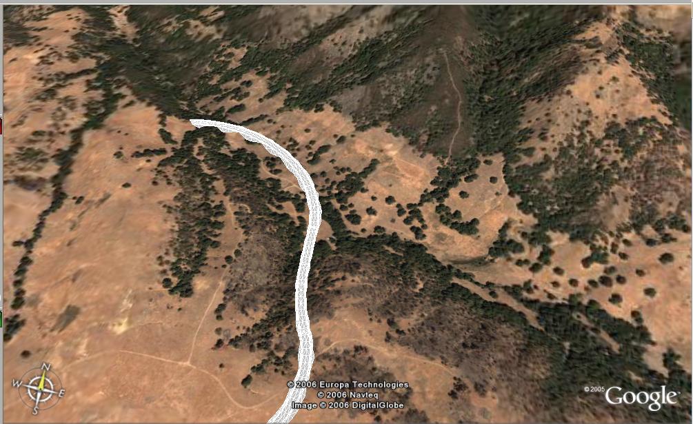
Autodesk made available yesterday the Autodesk Civil 3D 2007 Extension for Google Earth is a NEW Technology Preview that will allow Civil 3d 2007 users to publish significantly more to Google Earth than does the hidden command EXPORTGOOGLEEARTH.

This Extension will allow the exporting of Points, Parcels, Alignments, Corridor models, Surfaces, and Pipe Networks directly to Google Earth.

In order to install you must have both Civil 3D 2007 and any version of Google Earth (Free, Plus, Pro) installed.

Note: When you install you will get two drawings that you can practice exporting to Google earth

Wednesday, May 17, 2006

Civil 3D 2007 - Project Management Webcast!!!!

There are several reason why you will want to attend this Friday's 1 hour Civil 3D Webcast at 9:00 am Pacific time, 12:00 pm Eastern time. Not the least of which is the subject... "Project Capabilities in Civil 3D 2007". This is the first of two webcast related to this subject.

The Autodesk website describes the session as covering Vault, Vault Explorer, installation of Vault components, logging into Vault, creating projects, and other related topics.

It will be presented by Mark Scacco, President, Engineered Efficiency. Mark has a long history of being a very important resource in the Civil Engineering/Autodesk User community.

In order to benefit from the many enhancements to Civil 3D in a project environment we will need to use Vault. It is a separate application that is integrated with Civil 3D 2007 and is perhaps the most unfamiliar part of migrating to the 2007 product.

Lastly, these webcast are FREE and they are recorded for later viewing.


Upcoming topics include:

5/26/06 – Project and Data Management in Civil 3D 2007
6/2/06 – New Pipe Design and Drafting Capabilities in Civil 3D 2007
6/9/06 – Civil 3D 2007 Site Grading
6/16/06 – Civil 3D 2007 Tips & Tricks
6/23/06 – Increasing Productivity with Civil 3D 2007
6/30/06 - Civil 3D 2007 Corridor Modeling

Friday, May 05, 2006

Civil 3D 2007 - Corridor to Google Earth


There is so much to share, and not nearly enough time to do so. Here is a super quick item.

Today, during the webcast, Anthony Governanti, Technical Marketing Manager for Autodesk, shared a hidden command in Civil 3D 2007. EXPORTGOOGLEEARTH.

This command allows you to pick a corridor with a corridor surface in a drawing that has a coordinate system assigned and have the surface of the corridor exported to Google Earth.

Saturday, April 15, 2006

Bootcamp Day Five - Three Homeruns

Thursday was my fifth and final day at bootcamp. It turned out to be my favorite one.

Why? Well, Autodesk hit three homeruns with me. One for each of the subjects that I covered that day.

HOMERUN #1
Pipes: The additions to pipes were excellent. New rules for both pipes and structures. Structure properties that include pipe inverts that can be edited. Rules can be reapplied at my choosing. Create a network from a pline. Create an alignment from a network. Import LDT pipe runs. Interference checking for collisions or clearance (COOL!). New grips in profile.

HOMERUN #2
Corridors: Lots here too. Many new spiral types. Constrained profiles (similar to horizontal alignments, Fixed, Floating, Free). Floating parabolic curves can now end a profile. Three new transparent commands (profile station from plan view, profile station and elevation from plan view, and profile station and elevation from plan view and point). Profile geometry point can now be labeled in plan views. Customizable markers replace hard-coded ones. Quick profiles, which can include the baseline geometry itself. Two new profile bands: Sectional data and Pipe Network data. Corridors regions can have styles (outlines). Graphical edit can be done. Individual sections can be edited. Corridor surfaces are true surfaces on Prospector tab. 16 new subassemblies. Two new tables: Total Volumes, Materials.

HOMERUN #3
General Drafting: We will now have a Toolbox tab to the Toolspace. This will include reports, but can include custom created tools. Text masking can be added to ALL labels, they can also have a draw order specified. There is now a NOTE label for any text item. We can label basic lines and curves. Reference text in labels can be created from any combination of object(s). Expressions allow us to due math computation with object data (EXCELLENT!!!). We will be able to copy label components. Drag-and-Drop styles will now prompt to Overwrite or Rename. And perhaps my favorite of all EDIT INDIVIDUAL LABEL TEXT VALUES.

It was a very useful and educational week. As you can see there is much to learn, absorb, and incorporate into our habits. That being said, I am sure glad to be home.

I'll be back soon with more detailed posts.

Wednesday, April 12, 2006

Bootcamp Day Four - Survey and Grading

It has been four days, and there is only one to go. For as much information as has been shared, there is still much more to go over.

What does that mean? It means that there are a LOT of additions, improvements, and tweaks to Civil 3D in the 2007 version.

For example the new Survey capabilities. These not only replace what many may have used in the Autodesk Survey add-on to Land Desktop, but they do much more in an easier to use interface that speeds up corrections.

Take the ability to look at the observation object and see, based on the raw data, where the points will be located. Errors (busts) can be seen, easily corrected, and the fixed data converted into good cogo points.

I really enjoyed working with all of the new Feature Line tools. Considering the amount of users that do site grading that I've interacted with lately I know that these new tools will be VERY MUCH appreciated.

Like what you may ask? Certainly, the Stepped Offset command, (similar to the Create Curb command in LDT), was long overdue, but things like feature line vertex weeding, smoothing, fit curve, and filleting, to name a few, give us abilities that are easy to learn and we will want to use.

Tomorrow I will be seeing the new Corridor stuff. I can't wait.

Wednesday, March 29, 2006

Anthony's Thoughts

Today, many resellers attended a webcast that described what will be available for us to refer to, and what is in the box (Civil 3D 2007), that can be used to learn, teach, and guide.

One segment of the webcast presented by Anthony Governanti, Technical Marketing Manager for Autodesk, was the "Wicked Cool Stuff" according to him.

The following is his list (in no particular order):

Text masking! Available in all labels!
Expressions – add calculations to any label
Reference text (that can use...)
---Alignments
---Profiles
---Parcels
---Surfaces
General Note (object)
Quick Profile
DWF Preview for Project Data
Grading Feature Line tools (3D polyline tools and more)
Grading that works!
---Inside corner cleanup
---Projection to surface
Graphical Corridor Editing
New Subassemblies
---Retaining walls
---Channels
---Pipe trench
---Many more
New templates
---National CAD Standards (NCS) based
---Extended to include Civil 3D specific objects
---Includes styles to replicate LDT output
Too much to list!

Although, much of this information has been discussed here and elsewhere, it was certainly very useful for me to see Anthony's highlight reel.


PS. I want to thank Anthony for his OK to use his list.

Friday, March 24, 2006

Wow!

I just watched the weekly webcast in which Autodesk introduced Civil 3D 2007. The first thing that amazed me was the number of attendees. I noticed the peak at about 9:20 of over 980 attendees. Awesome.

OK, on to the important stuff.

Dave Simeone and Anthony Governanti did a great job of very quickly (they only had 1 hour) demonstrating some of the new capabilities. Much of it had already been described, here and in other blogs, but to see this live is very different.

I few memorable items for me were...

Labels with masks
Labels with expressions (formulas)
Labels that referenced multiple objects and object types
Generic Note with intelligent layout viewport resizing
The entirely revamped Help documentation
Better surface elimination of flat triangles
Quick Profiles
Inclusion of base feature line in Quick Profiles
Many new Grading Feature Line tools
Autodesk Vault to manage projects
Added project support for Pipes
Survey functionality (similar to Survey add-on to Land Desktop) in the box
Graphically edit Corridor model regions
Immediate creation of corridor surface in Prospector
Ability to graphically modify individual sections that affect corridor
Profile can contain fixed, floating, or free constraints (similar to horiz aligns)
Annotate Vertical Curve info in plan view
Interference checking for pipe networks
Import LDt pipe runs
Part Builder documented and exposed in UI
Replacement of VIZ Render with native AutoCAD tools

Whew!

They suggested that we all begin preparing for the arrival of 2007 which they stated will begin shipping in April.

Lastly, they answered eight and one half pages of questions asked via an input window.

Lots to process.

Wednesday, March 01, 2006

Civil 3D 2007


As Autodesk introduces the NEW family of 2007 products (shipping in the next month or two) there will be lots to talk about. Here we will focus of course on Civil 3D 2007. What will be there? What will not? I will mention a few general topics today with detailed posts in the near future.

Lets begin.

One of the most obvious additions to Civil 3D is the entirely new Survey functionality and the survey observation object.

The Project environment will now be managed by the core data management capabilities of Autodesk Vault. It will allow for the sharing of:

Points
Surfaces
Alignments
Profiles
Pipe Networks (NEW)
Survey Data (NEW)

Corridors will create named surfaces directly. We will no longer have to export non-associated surfaces. We will also be able to select an existing polyline as a corridor boundary (cool). There will be new subassemblies.

Profiles will now be element-based (free, floating, fixed). This allows for similar constraints as horizontal alignments.

Grading Feature Lines will be controlled by a new set of tools which include the ability, similar to LDt, to create offsets with elevational differences.

Quick sections will be able to be created from AutoCAD objects.

We will be able to create a Pipe Network from a polyline and create an alignment from an existing pipe network. Pipe interference detection will be possible.

Styles management will include the ability to Merge, Copy, or Rename any duplicates found during drag-and-drop operations.

Labels will be able to contain data from various object types in our models. We will be able to include expressions (formulas) in a label style. The labeling of lines, arcs and polylines with style based labels will be possible. I am confident that many will appreciate that masks will be able to be added to labels to hide object behind the label.

We will be able to reset a Point's elevations based on an existing surface. Changing an individual point's rotation angle graphically will be possible.

LandXML 1.1 support for survey and corridor data will help matters.

These are just a few of the enhancements that caught my eye. These plus those found in AutoCAD 2007 and Map 3D 2007 (because Civil 3D is built on top of these products) will give us lots benefit from.

OK, that is enough for now. As I said, I hope to add comments and details in the coming days, and weeks, as time permits.

Friday, January 27, 2006

Subassembly from Polyline - Enhanced


Creating a Subassembly from a polyline (CREATESUBFROMPLINE command) absolutely gives us a tremendous amount of flexibility to create any type of shape that we may wish to include in a corridor.

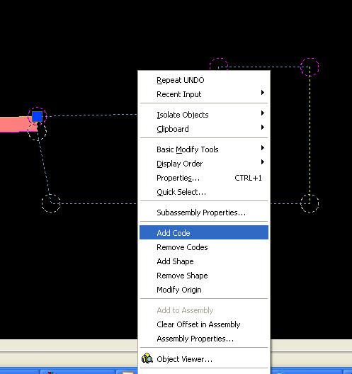
We can further enhance the Subassembly by adding CODES to the points, links, and shapes that make up the newly define Subassembly. This would give us the ability to define the TOP or DATUM links. We cound define points which would then connect with feature lines.

Simply Right-Click on the Subassembly that you create from a polyline and select "Add Code".

Tuesday, January 24, 2006

AU 2005 Top 12 Civil Track Classes


I just received info regarding the civil track classes at AU 2005 that had the most registrants.

If you are using AU Online (click title of this post above to connect) and want to see the classes that seemed to have a fair amount of interest you may find this list useful.

I am sure that prespective AU 2006 speakers will find this list of interest as well.


And the TOP 12 are:


Autodesk University 2005
Civil Engineering

CV32-2 Essentials of Site Grading with Autodesk® Civil 3D®
CV33-1 Advanced Site Grading with Autodesk® Civil 3D®
CV14-2 Autodesk® Civil 3D® Pipes: Storm Sewer Layout & Design
CV31-2 Autodesk® Civil 3D® Pipes Workshop
CV21-2 Essentials of Road Design with Autodesk® Civil 3D® 2006
CV13-3 Best of Both Worlds: Autodesk® Land Desktop and Autodesk® Civil 3D®
CV22-2 Autodesk® Civil 3D® Corridors: Cul-de-Sacs Are Not a Dead End
CV21-3 Think Outside the Contour: Grading in 3D
CV15-2 Essentials of Points and User-Defined Properties in Autodesk® Civil 3D®
CV41-4 Top 10 Autodesk® Land Desktop Tips and Tricks
CV35-3 Programming Corridor Assemblies in Autodesk® Civil 3D®
CV34-4 Amazing Grade - How Sweet the Ground

My class CV22-2 in turns out was the 7th most highly attended class out of the 41 classes in the Civil Track. As a first-timer, I am greatful for the experience.